About
MD. KAMAL HOSEN, a motivated and an ambitious Urban Planner, is mostly involved in the field of Planning and Geographic Information System (GIS). He has a three years of professional working experience in Urban Planning, GIS and Research field. Currently, he is working as a GIS specialist of a Master Plan Project at Asian Disaster Preparedness Center (ADPC). He has developed a Web-based GIS system for publishing, visualizing and managing geospatial data for municipal Govt. as a part of his MURP dissertation. He is comfortable and proficient in dealing with large scale geospatial data management and analysis.

Urban Planner | GIS Specialist | WebGIS Developer
- Birthday: 10 October 1995
- Website: www.mkhosen.com
- Phone: +880-1827 383076
- City: Rajshahi, Bangladesh
- Age: 25
- Degree: Master
- PhEmailone: plnkamalhosen@gmail.com
- Freelance: Available
Core Skills
- Urban Planning
- Land Use Planning
- Spatial Data Analysis
- GIS Modelling
- Geodatabase Management
- WebGIS Development
- Satellite Image Analysis
- Data Analysis and Report Writing
- Website Design
Technical Skills
GIS
WebGIS
Programming Language
Remote Sensing
Statistical Analysis
Databases
Website Design
Online Survey Tool
General
Others
Resume
Summary
Md. Kamal Hosen
Innovative, enthusiastic and deadline-driven GIS Specialist with 2+ years of professional experience in the field of urban planning, mapping, geospatial analysis, 3D GIS and web mapping.
- Uposhahor, Rajshahi, Bangladesh
- +880-1521 455202
- plnkamalhosen@gmail.com
Education
MASTER OF URBAN AND RURAL PLANNING (MURP)
2018 - 2020
Khulna University, Khulna-9208, Bangladesh
BACHELOR OF URBAN AND RURAL PLANNING (BURP)
2014 - 2018
Khulna University, Khulna-9208, Bangladesh
Online Courses
GIS, Mapping, and Spatial Analysis
July 2020
Offered by University of Toronto, Coursera
Spatial Data Science and Applications
July 2020
Offered by Yonsei University, Coursera
Spatial Analysis and Satellite Imagery in a GIS
July 2020
Offered by University of Toronto, Coursera
Geospatial and Environmental Analysis
July 2020
Offered by University of California, Davis, Coursera
Managing Data Analysis
July 2020
Offered by Johns Hopkins Uiniversity, Coursera
SQL for Data Science
July 2020
Offered by University of California, Davis, Coursera
Cartography
July 2020
Offered by Esri Academy
Spatial Data Science: The New Frontier in Analytics
July 2020
Offered by Esri Academy
The Location Advantage
July 2020
Offered by Esri Academy
Training and Workshops
Training on Building Plan Approval at Upazila Level
January, 2018
Arranged by Khulna University and BIP
Affiliation
Bangladesh Institute of Planners (BIP)
2018 - Present
Member
Work Experience
GIS Assistant
Asian Disaster Preparedness Center
April, 2019 - Present
Rajshahi, Bangladesh
- Assist in preparation of disaster risk sensitive Master Plan and Detail Area Plan
- Store, manage, clean, manipulate, checking and varification of GIS databases
- Analysis and assessment of environmental monitoring survey data
- Merging and joining mouza sheet
- Preparation of urban landuse zoning map
- Joining non-spatial survey data with GIS data
- Sampling and preparation of earthquake building vulverability survey map
- Assessment of building vulnerability
- Preparation of fire risk assessment map
- Converting Kobo toolbox survey data to GIS shapefile for map making
- Preparation of survey (socio-economic, geotechnical, environmental, traffic count, travel behavior etc.) location map from online (Kobo toolbox) survey data
- Spatial analysis and visualization of survey data
Research Assistant (PhD Student)
Cornell University College of Architecture, Art, and Planning
September, 2018 – November, 2018
Khulna, Bangladesh
- Assist in slum and water related data collection (by both quantitative and in-depth interview of Khulna City Corporation (KCC) & Khulna Water Supply and Sewerage Authority (KWASA) professionals, journalists and slum respondents)
- Data cleaning, manipulation and prepare for analysis
- Preparation of GIS map such as map of KWASA old & new distribution network, map of KCC slum, map of KWASA production well, poverty status map of KCC slum and so on)
- Analysis and assessment of spatial inequality of KWASA water distribution among slums households
- Monitoring and evaluation of field work through frequently field visit
- Accuracy checking of field data
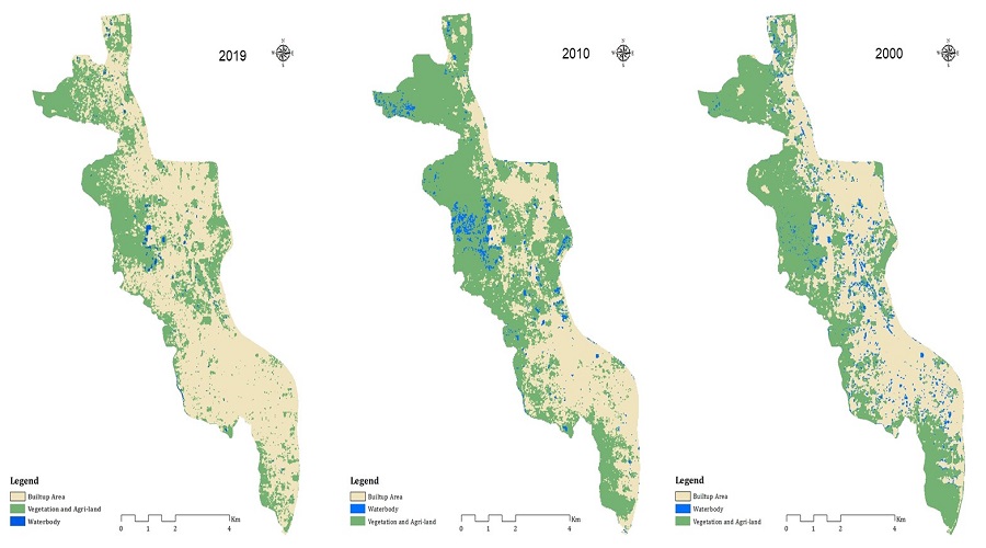
- Analysis of land use change of Khulna City over the period of 1990 to 2018
Junior Urban Planner
Tiller Ltd.
February, 2018 – June, 2018
Mirsharai, Chittagong, Bangladesh
- Design detail work plan and schedule of the projects
- Provide training and guidelines of the survey team to collect field data
- Management and co-ordination of survey team
- Manage and control of survey data
- Monitoring and evaluation of field work through frequently field visit
- Accuracy checking of field data
- Preparation of survey report
- Survey map geo-referencing and digitizing
- Design excel sheet and joining excel data into GIS data
- Data store, cleaning and manipulation
- Error corrections and finalize GIS data
INTERNSHIP
SMEC-ACE Consultants Ltd. Bangladesh
Decembar, 2017 – January, 2018
Dhaka, Bangladesh
- Preparation of Land Acquisition Plan (LAP)
- Geo-referencing, projection and digitizing of GIS map
- Preparation of Digital Elevation Model (DEM) map
- Develop a demo online survey system using Open Data Kit (ODK)
Research and Publications
Conference Paper
- Hosen, M.K., Islam, K.S., Chakraborty, T. (2019). Simulating the Impact of Setback, Floor Area Ratio (FAR) and Maximum Ground Coverage (MGC) Rules on Urban Living Environment: An Airflow Modelling Perspective, International Conference on Urban and Regional Planning-2019, Dhaka, Bangladesh.
- Hosen, M.K., Alam, M.S., Chakraborty, T., Noyon, M.E, K., Haque, S.M. (2019). GIS-Based Fire Hazard Risk Assessment of Residential Buildings of Rajshahi City Corporation Using Entropy-TOPSIS Integrated Approach, International Conference on Urban and Regional Planning-2019, Dhaka, Bangladesh.
Thesis/Dissertation
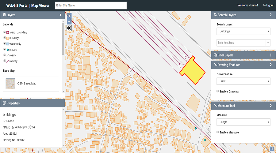
- MURP: A WebGIS Approach for Enhancing Municipal Services of Khulna City.
- BURP: Simulating the Impact of Floor Area Ratio (FAR) on Living Environment: A Case Study on Nirala Residential Area, Khulna, Bangladesh.

Contact Me
Are you interested to work with me? Please feel free to contact.
Location:
House No# 112, Sector-2, Uposhahor, Rajshahi, Bangladesh
Email:
plnkamalhosen@gmail.com
Call:
+880-1827 383076